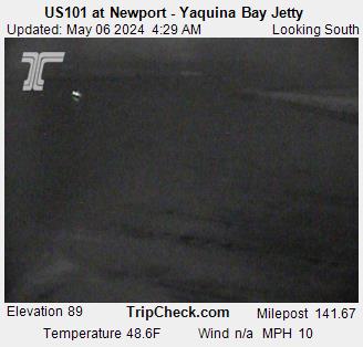
Live Camera

Yaquina Bay webcam
Auto-refreshes every 60s • Click to enlarge Source: ODOT TripCheck
Restricted Stale — 6h 42m old
Alerts
Last verified 6h 42m ago
Heads up: NOAA hasn't refreshed this bar's conditions in 6h 42m. The values below may be out of date — verify with the USCG bar station or alternative sources before crossing.
Where to verify:
Swell? 2-4 ft
Wind? 25 kts N
Visibility? 5+ nm
Updated 9:18 PM
Next check in --:--
USCG: ALL AREAS 2-4 FOOT SWELLS WINDS NORTH AT 20-25 KNOTS. VISIBILITY 07 NAUTICAL MILES THE BAR IS CURRENTLY RESTRICTED TO RECREATINAL VESSELS LESS THAN OR EQUAL TO 20 FEET IN LENGTH AND UNINSPECTED COMMERCIAL PASSENGER VESSELS LESS THAN OR EQUAL TO 16 FEET IN LENGTH AT BUOY NUMBER 7. Restrictions: Recreational:20 / Uninspected Passenger Vessels:16
VHF 16 Distress, Safety & Calling • 156.800 MHz
VHF 22A USCG Working Channel • 157.100 MHz

Call on VHF 16 first, switch to 22A when directed.

DISCLAIMER: Bar conditions change rapidly. Always contact the USCG bar station directly before crossing.

Marine Forecast — Cape Falcon to Florence

Rest Of Today SW wind to 5 kt. Wind waves SW 1 ft at 4 seconds. NW swell 2…
Tonight N wind to 5 kt. Wind waves N 1 ft at 4 seconds. NW swell 3 f…
View 4-period forecast

Marine Forecast Cape Falcon to Florence

Rest Of Today

SW wind to 5 kt. Wind waves SW 1 ft at 4 seconds. NW swell 2 ft at 9 seconds. Widespread dense fog and a chance of showers in the morning, then areas of dense fog in the afternoon.

Tonight

N wind to 5 kt. Wind waves N 1 ft at 4 seconds. NW swell 3 ft at 9 seconds. Areas of dense fog in the evening. Patchy dense fog after midnight.

Wed

N wind 5 kt. Wind waves N 1 ft at 4 seconds. NW swell 3 ft at 9 seconds. Patchy dense fog in the morning.

Wed Night

NW wind 5 kt. Wind waves W 1 ft at 4 seconds. NW swell 3 ft at 9 seconds.

Data from NOAA National Weather Service. Forecast updates every 6 hours.

7-Day Forecast

Monday 69°F · Partly Sunny
Tuesday 61°F · Mostly Sunny
View full 7-day outlook

7-Day Forecast

Monday
Partly Sunny
69°F
Partly Sunny
6 to 21 mph N
Tuesday
Mostly Sunny
61°F
Mostly Sunny
13 to 24 mph NNW
Wednesday
Sunny
59°F
Sunny
16 to 28 mph N
Thursday
Mostly Sunny
61°F
Mostly Sunny
13 to 22 mph N
Juneteenth
Mostly Sunny
59°F
Mostly Sunny
8 to 15 mph NNW
Saturday
Partly Sunny
59°F
Partly Sunny
6 to 12 mph NNW
Sunday
Mostly Sunny
60°F
Mostly Sunny
5 to 15 mph NNW

Data from NWS api.weather.gov. Use for trip planning - verify conditions closer to departure.

Tide Predictions

Station 9435380
Range Next 7 days, hourly
View tide chart

Tide Predictions (7 days)

Scroll to zoom, drag to pan

NOAA tide predictions for the next 7 days. Height in feet above Mean Lower Low Water (MLLW). Best bar crossing is typically during slack tide (between high and low).

Tide Predictions
Pinch to zoom, drag to pan

Tide height predictions chart. Data table follows.

Tide Height Predictions
Date/Time Height (ft) Type

View shareable Yaquina Bay tide forecast →

Tidal Currents

Now Slack
Next slack 8:46 AM
View crossing windows

Tidal Currents & Crossing Windows

Slack Water
Next Slack: 8:46 AM Est.

Optimal Crossing Windows (next 24h)

8:46 AM
2026-06-15
Slack (est.)
3:37 PM
2026-06-15
Slack (est.)
8:31 PM
2026-06-15
Slack (est.)
2:35 AM
2026-06-16
Slack (est.)
Slack times estimated from tide data. Verify with USCG before crossing.

Crossing Safety: Slack water (±30 min) is safest. Avoid crossing when strong ebb meets ocean swell - dangerous standing waves form at bar entrance.

Buoy 46097 — Newport Shelf

Wave -- ft
Wind 9 kts N
Water 51°F
Full gauges & 48h history

NDBC Buoy Conditions Newport Shelf (46097)

Real-time ocean conditions from the National Data Buoy Center (NDBC). Wave height, period, water temperature, and atmospheric data from offshore monitoring buoys.

Newport Shelf buoy

Station 46097

Wave Height

--

feet

Wave Dir

--°

--

Wind Speed

9

knots

Wind Dir

360°

N

Water Temp

51

°F

Air Temp

55

°F

Pressure

1015.8

mb

Observation: Jun 15, 2026 7:50 AM UTC | View on NDBC

Link copied to clipboard!

Buoy History (48h)

Wave + period Trend chart
View chart

Buoy History (48 Hours)

Scroll to zoom, drag to pan

Wave height (blue) and dominant wave period (orange) from the NDBC buoy over the last 48 hours. Longer wave periods typically indicate ocean swell; shorter periods suggest local wind waves.

Buoy History
Pinch to zoom, drag to pan

Buoy wave data chart showing wave height and period. Data table follows.

Buoy Wave Data (Last 48 Hours)
Date/Time Wave Height (ft) Wave Period (sec)

Prior Status Changes

Restricted
Jun 14, 9:18 PM
2.0–4.0 ft swell · 25.0 kts N · 7.0 nm vis
Recreational:20 / Uninspected Passenger Vessels:16
No Restrictions
Jun 14, 7:35 PM
2.0–4.0 ft swell · 25.0 kts N · 7.0 nm vis
No Restrictions
Restricted
Jun 14, 4:04 PM
2.0–4.0 ft swell · 20.0 kts N · 7.0 nm vis
Recreational:20 FOOT. / Uninspected Passenger Vessels:16 FOOT.

Recent Catches at Yaquina Bay

View All →
Catch by Cory Fiala
Cory Fiala
Catch by Cory
Cory
Share Your Catch